
Kong, Ivory Coast
Kong
Kpon | |
|---|---|
Town, sub-prefecture, and commune | |
 Traditional mosque architecture in Kong, in the regional Sudano-Sahelian style. | |
 Kong Location in Ivory Coast | |
| Coordinates: 9°9′N 4°37′W / 9.150°N 4.617°W | |
| Country | |
| District | Savanes |
| Region | Tchologo |
| Department | Kong |
| Elevation | 328 m (1,076 ft) |
| Population (2021 census)[2] | |
| • Total | 33,391 |
| • Town | 11,774[1] |
| (2014 census) | |
| Time zone | UTC+0 (GMT) |
Kong, also known as Kpon, is a town in northern Ivory Coast. It is a sub-prefecture of and the seat of Kong Department in Tchologo Region, Savanes District. Kong is also a commune. It was the capital of the Kong Empire (1710–1895).
Natural history[edit]
Kong is in the sub-Saharan Sahel–tropical Savanna belt biogeography region, of grasslands with trees, such as the baobab (Adansonia digitata), shea (Vitellaria paradoxa) and other species.
History[edit]
Kong emerged as a trading centre when Mali Empire merchants began trading in the territory of the surrounding Senufo people. The area from Kong to Dabakala is said to be the "origin" area, where Mandé traders known as the Dioula or Juula migrated from the Niger basin to settle in the 12th century.[3] These traders, of Soninke Wangara heritage, founded a series of towns along the trade route linking the Manding region to Hausaland, including Kong, Bondoukou, Bouna, and Begho.[4] The Juula brought with them their trading skills and connections, and transformed Kong into an international market for the exchange of northern desert goods, such as salt and cloth, and southern forest exports such as cola nuts, gold, and slaves.
As Kong grew prosperous from trade its early rulers from the Taraweré clan combined Juula and Senufo traditions, and extended their authority over the surrounding region.[citation needed] The town was islamized by Maraka traders in the 16th century.[5]
Kong Empire[edit]
In 1710, Seku Ouattara (Wattara), a Dioula warrior, invaded the area and conquered the city of Kong with his cavalry. He established himself as ruler and, under his authority, the city rose from a small city-state to the capital of the great Kong Empire. It held sway over much of the region for over 150 years. In the mid 18th century Kong was attacked by the Ashanti Empire.[5]
19th century[edit]
In the early 1890s Samory Touré, faama of the expanding Wassoulou Empire, set his sights on conquering Kong.[6]. The French, by that point the dominant power in the coastal region to the south, sought to secure the city by putting together a column led by Col. Monteil in August 1894, but it did not leave Grand Bassam, however, until February 1895. Its passage sparked a popular resistance movement.[7]: 269 Monteil fought a battle with Wassoulonke forces on the 14th, and the French were forced to retreat and abandon Kong, which pledged fealty to Samory in April.[8]
Toure accorded the city numerous privileges, but the local merchants' commerce with the coast, dominated by the French, slowed with their absorption into the Wassoulou empire. When Samory, looking to push further east into the Gold Coast to secure new sources of guns, retreated rather than fight a French force he encountered, they sought to take advantage of his weakness by intercepting arms caravans and opening channels to invite the French back.[9] When the discontent eventually broke into open revolt, Samory destroyed the city on May 23, 1897.[10]
In 1898 Kong came under French colonial control, within the French West Africa colony that had been created in 1893.
-
 A mosque in Kong, 1892.
 -
 People and costume of Kong, 1892.
 -
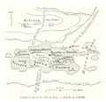 Map of Kong, 1892.
 -
 View of Kong.


Features[edit]
Despite the Kong Empire's fall from power, the 17th century Kong Friday Mosque survived. In the 20th century, it was largely rebuilt in a traditional earthen Sahelian architecture style. It features a Qur'anic school and distinctive baked mud mosque buildings. The Grand Mosque of Kong and another, smaller mosque within the city are inscribed on the UNESCO World Heritage List because of their traditional architectural style.[11]
The far north-eastern portion of the sub-prefecture is within the borders of Comoé National Park.
In 2014, the population of the sub-prefecture of Kong was 29,190.[12]
Villages[edit]
The 18 villages of the sub-prefecture of Kong and their population in 2014 are:[1]
- Djangbanasso (5 462)
- Kobada (1 323)
- Kong (11 774)
- Manogota (2 397)
- Djégnéné (964)
- Fassélémou (1 677)
- Kongodjan (173)
- Kongolo Sobara (283)
- Kongolo Tolo (1 543)
- Koundou (159)
- Limonon (432)
- Loronzo (166)
- Niangbakala (343)
- Paraka (565)
- Pongala (625)
- Sanzilo (357)
- Tiéménin (621)
- Tossienso (326)
References[edit]
- ^ a b Citypopulation.de Population of the localities in the sub-prefecture of Kong
- ^ Citypopulation.de Population of the regions and sub-prefectures of Ivory Coast
- ^ About African History: Timeline - Ivory Coast history Archived 2015-12-16 at the Wayback Machine; accessed 4.01.2011
- ^ Massing 2000, p. 294.
- ^ a b Massing 2000, p. 298.
- ^ Fofana 1998, p. 111.
- ^ Suret-Canale, Jean (1968). Afrique noire : occidentale et centrale (in French). Paris: Editions Sociales. p. 251. Retrieved 24 September 2023.
- ^ Fofana 1998, p. 112-3.
- ^ Fofana 1998, p. 116-7.
- ^ Ba, Amadou Bal (11 February 2020). "L'Almamy Samory TOURE (1830-1900), résistant et empereur du Wassoulou". Ferloo (in French). Retrieved 30 September 2023.
- ^ "Sudanese style mosques in northern Côte d'Ivoire". UNESCO World Heritage Centre. United Nations Educational, Scientific, and Cultural Organization. Retrieved 5 September 2021.
- ^ "RGPH 2014, Répertoire des localités, Région Tchologo" (PDF). ins.ci. Retrieved 5 August 2019.
Bibliography[edit]
- Appiah, Kwame (2003) Africana: The Concise Desk Reference
- Baumann, Gerd (2004) Grammars of Identity/Alterity: A Structural Approach
- Fofana, Khalil (1998). L' Almami Samori Touré Empereur. Paris: Présence Africaine. ISBN 978-2-7087-0678-1. Retrieved 30 September 2023.
- Forrest, Joshua (2004) Subnationalism in Africa: Ethnicity, Alliances, and Politics
- Massing, Andrew (2000). "The Wangara, an Old Soninke Diaspora in West Africa?". Cahiers d’Études Africaines. 40 (158): 281–308. Retrieved 24 May 2024.
Regional seat: Ferkessédougou | ||
| Ferkessédougou Department |  | |
| Kong Department | ||
| Ouangolodougou Department | ||
* also a commune | ||
| International | |
|---|---|
| National | |