Portal:San Francisco Bay Area
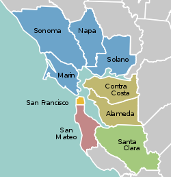
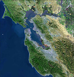
The San Francisco Bay Area Portal  The San Francisco Bay Area (referred to locally as the Bay Area) is a populous region surrounding the San Francisco and San Pablo estuaries in Northern California. The region encompasses the major cities and metropolitan areas of San Jose, San Francisco, and Oakland, along with smaller urban and rural areas. The Bay Area's nine counties are Alameda, Contra Costa, Marin, Napa, San Francisco, San Mateo, Santa Clara, Solano, and Sonoma. Home to approximately 7.68 million people, the nine-county Bay Area contains many cities, towns, airports, and associated regional, state, and national parks, connected by a network of roads, highways, railroads, bridges, tunnels, and commuter rail. The combined statistical area of the region is the second-largest in California (after the Greater Los Angeles area), the fifth-largest in the United States, and the 43rd-largest urban area in the world with 8.80 million people. The Bay Area has the second-most Fortune 500 companies in the United States, after the New York metropolitan area, and is known for its natural beauty, liberal politics, entrepreneurship, and diversity. The area ranks second in highest density of college graduates, after the Washington, D.C. metropolitan area and performs above the state median household income in the 2010 census; it includes the five highest California counties by per capita income and two of the top 25 wealthiest counties in the United States. Based on a 2013 population report from the California Department of Finance, the Bay Area is the only region in California where the rate of people migrating in from other areas in the United States is greater than the rate of those leaving the region, led by Alameda and Contra Costa counties. (more...) Selected article Selected biography After the Watts Riots of 1965, Assemblyman Ryan took a job as a substitute school teacher to investigate and document conditions in the area. In 1970, he investigated the conditions of California prisons by being held, under a pseudonym, as an inmate in Folsom Prison, while presiding as chairman of the Assembly committee that oversaw prison reform. During his time in Congress, Ryan traveled to Newfoundland to investigate the practice of seal hunting. Ryan was also famous for vocal criticism of the lack of Congressional oversight of the Central Intelligence Agency (CIA), and authored the Hughes–Ryan Amendment, passed in 1974. He was awarded the Congressional Gold Medal posthumously in 1983. (more...) Selected city Mill Valley is located on the western and northern shores of Richardson Bay. Beyond the flat coastal area and marshlands, it occupies narrow wooded canyons, mostly of second-growth redwoods, on the southern slopes of Mount Tamalpais. The Mill Valley 94941 ZIP code also includes the following adjacent unincorporated communities: Almonte, Alto, Homestead Valley, Strawberry and Tamalpais Valley. The Muir Woods National Monument is also located just outside the city limits. (more...) Selected image
The Bay Area by year1987

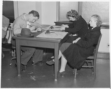
Selected historical imageDid you know...
Previous Did you know...
July/August 2011 Selected periodic event FanimeCon is an annual anime convention. It is the largest anime convention in Northern California and the 5th largest North American anime convention as of 2013. It has been held at the San Jose Convention Center since 2004. (Zack Fair and Aerith Gainsborough cosplayers pictured) Quote
Selected multimedia fileBay Area regions, geographic features and protected areasRelated PortalsWikiProject
Things you can do *Write an article on a Bay Area-related subject Selected panorama California-Stanford football game, Berkeley, Nov. 22, 1930. The Stanford Cardinals shut out the California Golden Bears 41-0. image credit: Morton & Co.
San Francisco Bay Area categoriesBay Area | San Francisco Bay | San Francisco | San Jose | Oakland | Cities | Census-designated places | Historic Places | National Landmarks | Counties: Alameda | Contra Costa | Marin | Napa | San Mateo | Santa Clara | Solano | Sonoma
Architecture | Attractions | Books | Culture | Economy | Education | Environment | Events & Festivals | Geography | Government | History | Landmarks | Law | Mass media | Military | Music | Organizations | Parks | People | Politics | Science | Sports | Transport
Full category tree
Select [►] to view the full category tree.
Associated WikimediaThe following Wikimedia Foundation sister projects provide more on this subject:
Discover Wikipedia using portals |
- All portals
- San Francisco Bay Area portal
- San Francisco Bay Area portal selected article pages
- San Francisco Bay Area portal selected biography pages
- San Francisco Bay Area portal selected city pages
- San Francisco Bay Area portal selected picture pages
- San Francisco Bay Area portal years pages
- San Francisco Bay Area portal selected historical image pages
- San Francisco Bay Area portal did you know pages
- San Francisco Bay Area portal festivals pages
- San Francisco Bay Area portal quotes pages
- San Francisco Bay Area portal selected multimedia pages
- San Francisco Bay Area portal selected panorama pages
- California portals
- San Francisco Bay Area
- United States portals by city


