
Csabdi
An editor has nominated this article for deletion. You are welcome to participate in the deletion discussion, which will decide whether or not to retain it. |
You can help expand this article with text translated from the corresponding article in Hungarian. (June 2024) Click [show] for important translation instructions.
|
Csabdi | |
|---|---|
| Csabdi | |
 Coat of arms | |
 Csabdi Location of Getto | |
| Coordinates: 47°31′23″N 18°36′37″E / 47.52302°N 18.61016°E | |
| Country | Hungary |
| County | Fejér |
| Area | |
| • Total | 16.87 km2 (6.51 sq mi) |
| Population (2004) | |
| • Total | 1,174 |
| • Density | 69.59/km2 (180.2/sq mi) |
| Time zone | UTC+1 (CET) |
| • Summer (DST) | UTC+2 (CEST) |
| Postal code | 2064 |
| Area code | 22 |
| Motorways | M1 |
| Distance from Budapest | 40.8 km (25.4 mi) East |
| Website | www |
Csabdi is a village in Fejér county, Hungary.[1]
Gallery[edit]
-
 Saint László Church
 -
 Szabadság Street, with the Reformed Church in the background
 -
 Szabadság street after the cemetery, looking towards Nagyegyháza
 -
 Csabdi Reformed Church
 -
 After the festive service inside the Reformed church
 -
 Temple ruin with stage
 -
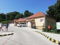 The courtyard of the village hall
.jpg)
.jpg)
.jpg)
.jpg)
.jpg)
.jpg)
.jpg)
References[edit]
Ember, István. (1970). A felszabadulás a bicskei járásban [Liberation in the district of Bicske]. Bicske: Az MSZMP Bicskei Járási Bizottsága és a Bicskei Járási Tanács Végrehajtó Bizottsága. pp. 148, illustrations 25 cm. OCLC 560239366.
- ^ "Fejér megyei kistérségek összehangolt stratégiai programja" (PDF). Sárvíz Térségfejlesztő Egyesület. 2001. pp. 29–34. Archived from the original (PDF) on 2013-05-15. Retrieved 2012-07-11.
External links[edit]
 Media related to Csabdi at Wikimedia Commons
- Street map (in Hungarian)
- Pictures, videos about Csabdi events
- Csabdi's story
- The data sheet of the Csabd church ruin on Műemlékem.hu
- Csabdi map and description on funiq.hu
- Pictures, videos about Csabdi events


| International | |
|---|---|
| National | |
This Fejér location article is a stub. You can help Wikipedia by expanding it. |